
Learjet 60: Icing Potential and Convective Hazards at Cruise Altitude
A cautious multisensor reconstruction using GOES-19 infrared imagery, NEXRAD radar, and ADS-B flight data.
Why cruise altitude does not eliminate storm risk
On 1 November 2026, Learjet 60 N722BD was involved in an accident near Palm Beach County, South Florida. Flight-track and publicly reported air-traffic information describe icing, moderate turbulence and precipitation before a rapid descent. These reports motivate a meteorological reconstruction, but do not themselves establish the accident cause.
Observations from three complementary systems
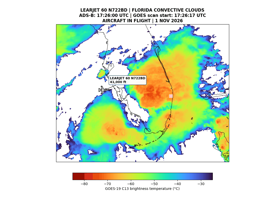
GOES-19 ABI Band 13 infrared imagery shows a broad, cold cloud shield over South Florida. Exploratory analysis estimated approximately 225,000 km² of connected cold cloud cover at a brightness-temperature threshold of ≤ −32°C near the event time. The pattern is suggestive of organized convection on the mesoscale, consistent with general Mesoscale Convective System (MCS) characteristics, but this area has not been validated as one coherent convective system. Although some cloud-area thresholds relevant to a Mesoscale Convective Complex (MCC) may have been exceeded, MCC classification still requires verification of cloud continuity, persistence for at least six hours, and system geometry.
Aircraft position relative to deep convection
ADS-B data place the aircraft near flight level FL350 (about 35,000 ft, or 10.7 km) at approximately 17:46 UTC. Infrared cloud tops were very cold around the flight corridor. Cold cloud-top temperatures are consistent with deep cloud development, but neither reveal the exact cloud phase at aircraft altitude nor prove that the aircraft traversed a particular storm core.
Reading the NEXRAD vertical curtain
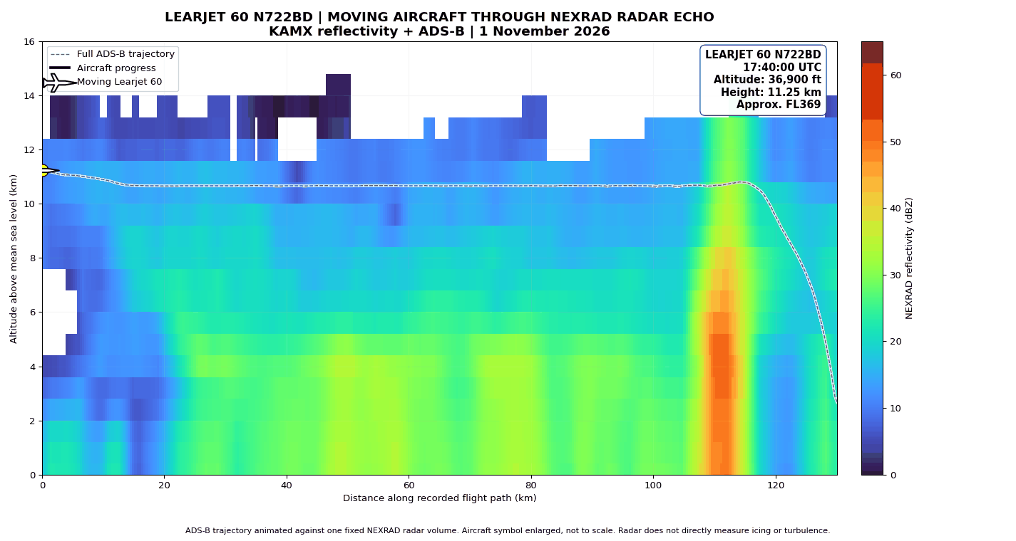
The exploratory NEXRAD KAMX reflectivity curtain displays radar echoes at multiple altitudes along a reconstructed flight-path transect. Because the radar volume was sampled and interpolated in space and time, it must not be mistaken for instantaneous measurements at the moving aircraft. Radar reflectivity does not directly measure vertical gusts, icing, supercooled liquid water, or ice-crystal concentrations.
Icing potential, turbulence and other hazards
Deep convection may contain large vertical air motions, sharp wind gradients, mixed-phase water and ice, and regions of high ice-water content. These create plausible hazards to aircraft, including turbulence, conventional airframe icing in suitable temperature layers, and possible ice-crystal icing affecting engines or instruments. Lightning is also a general convective hazard. For this particular flight, these mechanisms remain hypotheses requiring additional atmospheric and aircraft evidence, not established causes.
What the reconstruction can — and cannot — conclude
The combined observations show a meteorological setting in which convective aviation hazards were plausible. They do not determine whether Learjet N722BD experienced severe turbulence or icing, or whether either caused the loss. Such conclusions require the official safety investigation, verified communications and flight records, and time-aligned meteorological observations. The scientific value of this reconstruction lies in transparently separating evidence, physical interpretation and uncertainty.
Sources & editorial notes
Sources: NOAA GOES-19 ABI Band 13 and NEXRAD KAMX; processed ADS-B records; independent technical brief and working manuscript by Deni Septiadi and collaborators. Related background: NTSB investigation ERA27MA026.
Independent scientific case study, not an official NTSB investigation or an assessment of probable cause. Icing, turbulence, and storm classification remain subject to verification.
Learjet 60: Potensi Icing dan Bahaya Cuaca Konvektif pada Ketinggian Jelajah
Rekonstruksi multisensor dengan interpretasi hati-hati berdasarkan inframerah GOES-19, radar NEXRAD, dan data penerbangan ADS-B.
Mengapa ketinggian jelajah tidak menghilangkan risiko badai
Pada 1 November 2026, Learjet 60 N722BD mengalami kecelakaan di sekitar Palm Beach County, Florida Selatan. Informasi lintasan penerbangan dan laporan komunikasi lalu lintas udara menyebut adanya icing, turbulensi sedang, dan presipitasi sebelum pesawat mengalami penurunan cepat. Laporan tersebut menjadi alasan melakukan rekonstruksi meteorologi, tetapi tidak dengan sendirinya menetapkan penyebab kecelakaan.
Tiga jenis observasi yang saling melengkapi
Citra inframerah GOES-19 ABI Band 13 memperlihatkan perkembangan selubung awan dingin yang luas di Florida Selatan. Analisis eksploratif menghasilkan estimasi sekitar 225.000 km² untuk kelompok awan dingin yang terhubung pada ambang temperatur kecerahan ≤ −32°C menjelang kejadian. Pola tersebut menunjukkan kemungkinan organisasi konveksi pada skala meso yang konsisten dengan karakteristik umum Mesoscale Convective System (MCS), tetapi luasan ini belum tervalidasi sebagai satu sistem tunggal. Beberapa ambang luasan awal Mesoscale Convective Complex (MCC) mungkin terlampaui; klasifikasi MCC tetap memerlukan verifikasi kontinuitas awan, persistensi setidaknya enam jam, dan bentuk geometris sistem.
Posisi pesawat terhadap lingkungan konvektif
Data ADS-B menunjukkan pesawat berada di sekitar FL350 (35.000 kaki atau 10,7 km) pada kira-kira 17.46 UTC. Puncak awan dengan temperatur kecerahan sangat rendah teramati di sekitar koridor penerbangan. Puncak awan dingin konsisten dengan perkembangan awan dalam, tetapi tidak dapat menunjukkan fase mikrofisika tepat pada ketinggian pesawat ataupun membuktikan bahwa pesawat memasuki inti badai tertentu.
Menafsirkan penampang vertikal NEXRAD
Penampang vertikal reflektivitas NEXRAD KAMX yang bersifat eksploratif memperlihatkan echo radar pada berbagai ketinggian di sepanjang lintasan yang direkonstruksi. Volume radar diamati dan diinterpolasi dalam ruang dan waktu, sehingga bukan pengukuran sesaat yang tepat mengikuti pesawat bergerak. Reflektivitas radar tidak mengukur secara langsung hembusan vertikal, icing, air superdingin, ataupun konsentrasi kristal es.
Potensi icing, turbulensi, dan bahaya lainnya
Konveksi dalam dapat mengandung gerakan udara vertikal kuat, gradien angin tajam, campuran air dan es, serta kandungan kristal es yang tinggi. Kondisi ini berpotensi menimbulkan turbulensi, pembentukan es pada permukaan pesawat di lapisan suhu yang sesuai, serta ice-crystal icing pada komponen tertentu. Petir merupakan bahaya umum dalam badai konvektif. Pada penerbangan ini, mekanisme tersebut tetap berupa hipotesis yang membutuhkan bukti tambahan, bukan penyebab yang sudah terbukti.
Apa yang dapat dan tidak dapat disimpulkan
Gabungan pengamatan menunjukkan lingkungan meteorologi yang berpotensi mendukung bahaya cuaca konvektif. Data tersebut belum menentukan apakah Learjet N722BD benar-benar mengalami turbulensi berat atau icing, terlebih apakah keduanya menyebabkan kecelakaan. Kesimpulan itu memerlukan investigasi keselamatan resmi, verifikasi rekaman penerbangan, dan observasi meteorologi yang tersinkronisasi. Nilai ilmiah rekonstruksi ini adalah memisahkan bukti, interpretasi fisik, dan ketidakpastian secara transparan.
Sumber dan catatan editorial
Sumber: NOAA GOES-19 ABI Band 13 dan NEXRAD KAMX; rekaman ADS-B yang telah diolah; technical brief independen dan manuskrip kerja Deni Septiadi beserta kolaborator. Konteks tambahan: investigasi NTSB ERA27MA026.
Studi kasus ilmiah independen, bukan investigasi resmi NTSB atau penentuan penyebab kecelakaan. Icing, turbulensi, dan klasifikasi sistem badai masih memerlukan verifikasi.